


057028 - MOUNTAIN ROAD Voting District, Cherokee County, Georgia
About
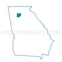
Outline

Summary
| Unique Area Identifier | 560654 |
| Name | 057028 - MOUNTAIN ROAD Voting District |
| County | Cherokee County |
| State | Georgia |
| Area (square miles) | 6.91 |
| Land Area (square miles) | 6.78 |
| Water Area (square miles) | 0.13 |
| % of Land Area | 98.08 |
| % of Water Area | 1.92 |
| Latitude of the Internal Point | 34.13796560 |
| Longtitude of the Internal Point | -84.39856190 |
Maps


Graphs
Select a template below for downloading or customizing gragh for 057028 - MOUNTAIN ROAD Voting District, Cherokee County, Georgia


Neighbors
Neighoring Voting District (by Name) Neighboring Voting District on the Map
- 057002 - ARNOLD MILL Voting District, Cherokee County, GA
- 057003 - AVERY Voting District, Cherokee County, GA
- 057008 - BRADSHAW Voting District, Cherokee County, GA
- 057019 - HICKORY FLAT Voting District, Cherokee County, GA
- 121ML01A - ML01A Voting District, Fulton County, GA
- 121ML02A - ML02A Voting District, Fulton County, GA
- 121RW09 - RW09 Voting District, Fulton County, GA
Top 10 Neighboring County Subdivision (by Population) Neighboring County Subdivision on the Map
- Roswell-Alpharetta CCD, Fulton County, GA (255,812)
- Woodstock CCD, Cherokee County, GA (92,804)
- Holly Springs CCD, Cherokee County, GA (51,788)
Top 10 Neighboring Place (by Population) Neighboring Place on the Map
Top 10 Neighboring Unified School District (by Population) Neighboring Unified School District on the Map
Top 10 Neighboring State Legislative District Lower Chamber (by Population) Neighboring State Legislative District Lower Chamber on the Map
Top 10 Neighboring State Legislative District Upper Chamber (by Population) Neighboring State Legislative District Upper Chamber on the Map
- State Senate District 48, GA (198,933)
- State Senate District 21, GA (171,113)
- State Senate District 56, GA (160,877)
Top 10 Neighboring 111th Congressional District (by Population) Neighboring 111th Congressional District on the Map
Top 10 Neighboring Census Tract (by Population) Neighboring Census Tract on the Map
- Census Tract 115.04, Fulton County, GA (12,406)
- Census Tract 115.03, Fulton County, GA (8,782)
- Census Tract 908.04, Cherokee County, GA (8,585)
- Census Tract 909.01, Cherokee County, GA (7,119)
- Census Tract 908.02, Cherokee County, GA (6,642)